La Madre Springs trail starts at the Willow Springs Parking lot. If you have 4-wheel drive vehicle, you can drive up Rocky Gap Road and park closer to the beginning of the trail, or you can drive up Rocky Gap Road that goes in the opposite direction of La Madre Springs trail near the trailhead sign.
This tail is a 3.6 mile an up and back hike that is mostly uphill to the dam and then back down to the trail head. The views are amazing from grey and white striated mountains in one directions, to red and white sandstone cliffs and amazing white bumping cliffs in the other directions.
You can also hike up Rocky Gap Road for some amazing views of the valley below and steep, rocky cliffs forming deep rocky washes. Keep your eyes out for deer and bighorn sheep.
Two men climbing a boulder off of Rocky Gap Road. This road goes in the opposite direction of La Madre Springs Trail
Dead tree in the wash next to Rocky Gap Road in Red Rock Canyon.
La Madre Springs Trail
Juniper - La Madre Trail - Red Rock Canyon NCA
Along the La Madre Springs Trail - Red Rock Canyon NCA
Trail head of La Madre Springs Trail
View from La Madre Springs Trail - Red Rock Canyon, NCA
View from La Madre Springs Trail - Red Rock Canyon NCA
Hikers on Rocky Gap Road - View from La Madre Springs trail.
Prickly pear cactus, yucca, and Pinyon Pine tree on the La Madre Springs Trail
Prickly Pear Cactus on the La Madre Springs Trail
Prickly Pear Cactus on the La Madre Springs Trail
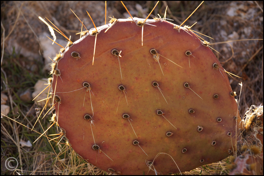
Prickly Pear Cactus on the La Madre Springs Trail
View from Rocky Gap Road near La Madre Springs Trail
The cholla forest in Lake Mead NRA is a interesting place to visit if you have a 4-wheel drive vehicle. From Boulder City take 93 towards the Hoover Dam.
Before you get to Lakeshore Road there is a turn off onto a dirt road (Hemenway Wash Road) on the left. There are some old building to the right of the turn off.
Cholla Cactus Forest in Lake Mead NRA
Drive past the powerline roads until you see a route sign. Turn left and drive up this road a couple of miles until you see the road split. Park next to the "Authorized vehicles only" sign. Hike about 1/4 mile up this road until you see the cactus on the hillside to your right. Be sure to bring some kitchen tongs and tweezers to remove any cactus that "jump" onto you. Look for small bird's nest in the cactus.
Arch on Many Canyons Trail
Large Boulder on Many Falls Canyon Trail
View of Lake Mead from Many Falls Canyon Trail
View on Many Falls Canyon Trail
View from Many Falls Canyon Trail
You can get on Many Falls Canyon Trail by backtracking from the Cholla Forest back to Hemenway Road. Continue on this road until you see the water tank. Park behind the water tank and hike up the wash. The wash will split into two canyons. The canyon to the right is Many Falls Canyon. This is the easier of the two canyons. Follow the wash up as far as you can go.
You can also access this trail from Cottonwood Tree Road across from Lake Mead RV Village.
Cold Creek is on the northern end of Mt. Charleston. It is right after the second exit to Mt. Charleston. This is a beautiful are with access to hike up Mt. Charleston. If you go in the early spring you will see lots of wild flowers. There is a herd of wild horses that live in this area and some small lake that are popular with fishermen.
This beautiful, short hike is in Henderson, NV. Hike a mile to the start of the canyon from the River-Mountain Bike trial. You will see steep cliffs that bighorn's love to hang out on, huge boulders that you can crawl under, and beautiful views towards Lake Las Vegas, Henderson, and Las Vegas.
To get to this canyon from Racetrack Road in Henderson, turn towards the desert on Essex Ave. Keep on the road until it turns into a dirt road and comes to a parking area next to the River-Mountain Bike Path. The canyon is basically straight back over the hill towards Lake Mead. You can take the road behind the water tank and then turn right into the wash before the second water tank. Follow the wash to to the canyon.
Arrow Canyon is a very interesting hike. The steep, slanted and sometimes curved walls makes it a unique place. You will see canyon walls scattered with barrel cactus, petroglyphs, and trees growing out of cracks in the rock walls. If you take this hike early in the season, February and March, you will see the bottom of the canyon covered in green grass in many areas. This is a great place to see bighorn sheep so keep your eyes out for them on the steep cliffs.
Caution: Although this hike is fairly flat with very little elevation gain, I found it to be quite difficult because of the small and large rocks littering the bottom of the canyon. It is slow walking because you have to be careful where you place your feet. You have to stop a lot to look around because you really can't look while you are walking or you will trip and fall.
To get here take Interstate 15 to the Moapa, Exit 90 about 53 miles from Henderson less from Las Vegas. Drive up Highway 168 about 19 miles until you see the entrance to Arrow Canyon Access Road. There is no sign next to the road. It is the dirt road right after Warm Springs Road. It looks like an entrance to a ranch. You will see the sign after turning onto the road.
This access road starts our great but you must bear right onto the dirt road after only a short distance. It doesn't look much like a road, but it isn't too bad to the first parking area. The road after the first parking area is quite bumpy and in some places very uneven. Don't take it if you don't have a high clearance four-wheel drive vehicle. The first parking lot is about a mile from the second one, so you will be adding two miles to your hike, but it is worth not destroying your vehicle or getting stuck in the sand and having to pay for a tow.
Bootleg Canyon - POW and Mother Trail - Boulder City, NV
Bootleg Canyon is only 30 minutes from Henderson, NV in Boulder City. You can actually hike the trails that start in Henderson and hike up to Boulder city. These are mountain bike trails and you must watch out for bikers and get off the trail so they can pass. Also try not to knock rocks down into the trails because they can be hazardous to bikers.
I started this hike at the trailhead near the Veterans Memorial Hospital. I followed the POW trail to the Mother trail going towards and behind the golf course which took about an hour to an hour and a half because I stopped a lot for pictures. I found a lone bighorn that didn't seem afraid of my presence. I was able to film it with my long lens with no problem. The bighorn sheep have been experiencing a decline because a pneumonia virus. This may be why this ewe seemed to be all by herself. The footage and stills were all filed within the three hours that I was on the trail this morning.
Bighorn sheep watching us from West Leg trail near Bootleg Wash in the River Mountains.
Bootleg Canyon Bighorn sheep location.
Watch a video I made of Bootleg Canyon and the Bighorn Sheep
Bootleg Canyon is an internationally famous mountain biking area. Bikers have the right-of-way. Always be aware of bikers on the trails and get off the trail when they are coming so they don't have to stop. Most of the trails are very narrow, often on steep cliffs and the bikers cannot stop easily.
View of Las Vegas in the background. You can see Las Vegas, Lake Las Vegas, Henderson and Boulder City from Bootleg Canyon.
There are many trailheads and trails that go into Bootleg Canyon. We parked at the trailhead near the Veterans Memorial Hospital and took the POW trail up towards the mountains. See a map of the Canyon for more details. There are many trails in the area and it can get confusing which one you are actually on especially if you go off trail. Some of the trails are marked but others aren't.
The trails go from Boulder City to Henderson. To make it easier, you can use two cars and just hike from Boulder City down to Henderson where you have a second car.